Thursday, June 30, 2011

RV Trip Part 8 - Home Again, Home Again, Jiggedy Jig

Our last night in the RV was spent where we started, Gallup. While we looked for vestiges of old Route 66, nothing noteworthy was witnessed. The last leg in BB was to drive back to Albuquerque and return it to CrusieAmerica. That went without incident and we bade our home for the last seven days a fond farewell.

We spent a few hours wandering Old Town in Albuquerque. We had lunch in the Church Street Cafe, which is set in a house built in 1706. While the setting was very cool, the food was "meh". I think this was our first meal in a restaurant in over a week. We had become used to quality RV food!

Not long out of Albuquerque, we left the mountains and hills behind and were back on the "flat, treeless, desolate plains". Just west of Amarillo we stopped to leave our mark on that wonderful piece of Americana, the Cadillac Ranch.

Conceived as an art project, in 1974, ten Cadillacs ranging from 1949-63 were buried nose first in a wheat field just outside of Amarillo. They were moved two miles further east along I-20 in 1997 to escape the growth of the city. They are allegedly installed at the same angle as the Great Pyramid in Egypt. Art, maybe. Great conversation, definitely.

Sunset on Cadillac Ranch

Tagging the cars with your favorite color spraypaint is encouraged. For the kids, this was a highlight of the trip... and cost nothing.

Initially we had planned to stay the night in Amarillo but we felt since we were back in Tejas, we might as well keep on trucking. Albuquerque to Dallas is 651 miles - so we were dog tired when we rolled into the driveway at 2am on Sunday morning. The journey was complete, some 2900 miles covered in TX, NM, UT, AZ and briefly CO. No major incidents, everyone accounted for, some great memories, I'd call it a success.

Beirne Brightly

Wednesday, June 29, 2011

RV Trip Part 7 - Sedona

Leaving the G.C. we headed south through Flagstaff and on to Sedona. We stayed in a very pretty RV park dotted with mature trees. While we cooked dinner, the boys played the World Championship of Bucket Hacky-Sack (not sure who won) and whittled sticks with their new pocket-knives.

Next morning a Pink Jeep met us at the park and took us out to explore the red rocks for which Sedona is famous. Our driver was great - a Larry David type - funny and very knowledgable of the area. We spent two hours driving up the sides of the mountain at impossible angles and descending down precipitous ravines. I got a whole new appreciation for good tires, four-wheel drive and of course, the legendary Jeep. It is cat-like.


Afterwards when checking out at the RV park office, I asked the manager what would she suggest we do for the rest of our time in Sedona. She immediately starting rattling off State Parks where the rocks and views were spectacular. It was then I realized we had done nothing but look at rocks for six days and it was time to get back to civilization. So we headed for Jerome, an old mining town, but not before we stopped at the Chapel of the Holy Cross. This might be one of the most pictuturesque churches in the US. Built in 1956 by Marguerite Bruswig Staude, a student of Frank Llyod Wright, it is an impressive structure that sits on the rocks as if it had always been there (I know, more rocks).


Jerome, on the other had, was once known as "the wickedest town in the west" where miners cavorted in saloons with the ahem, "ladies". Built by the riches of the cooper mines starting in 1883, it once boasted a population of several thousand, it is now down to several hundred and one excellent joke shop.


After ice cream and a stroll up and down both sides of the town, it was time again to saddle up and hit the interstate as we began to turn east and head back towards home. One more stop: The Meteor Crater near Winslow (yes, that Winslow, as in "I was standing on a corner in Winslow Arizona...").

The crater might be one of the world's biggest - close to a mile wide - and most intact but in terms of admission fees, what a gyp. Veni, vidi, vici. We left grumpy and about $50 poorer. (Point being, it cost $25 to get into the Grand Canyon).

My pics were lousy, I borrowed this one from Wikipedia...


And so on to Gallup for the night. Our last full day with BB was complete.

Sunday, June 26, 2011

RV Trip Part 6 - Grand Canyon National Park

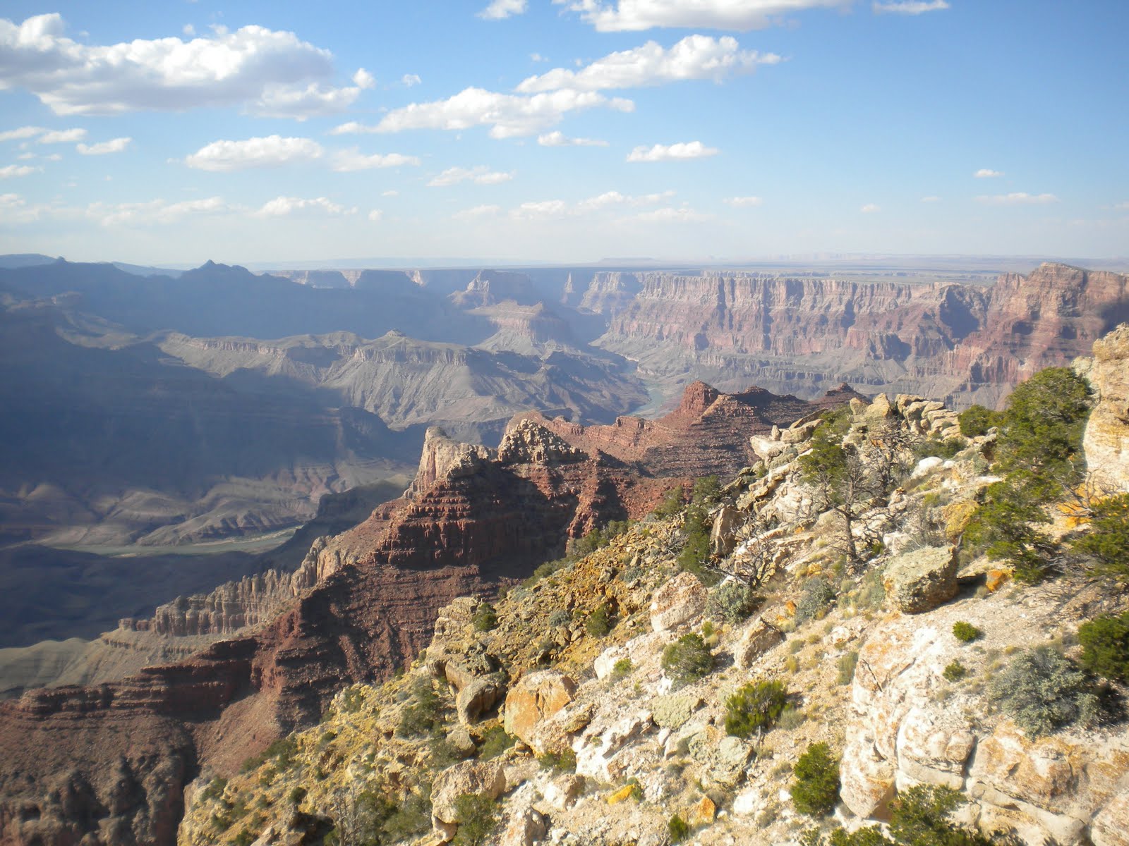
Superlatives abound when it comes to the Grand Canyon. Over 270 miles long, 17 miles across at its widest point and over one mile deep, it almost defies description. Its origins are estimated to be around 17 million years old. A combination of the Colorado River and wind, rain and ice have carved out what is usually listed among the Seven Wonders of the Natural World. Hard to disagree. There are over 20 different layers of rock from top to bottom and while the Colorado Plateau continues to be pushed upwards, the river continues to grind downwards, so each year, the canyon gets a little bigger...

Driving in from the east, we climbed steadily from an altitude of about 4,000 feet at Cameron to over 7,000 feet at the South Rim. Our first sight of the Grand Canyon was at Desert View. Here we stopped for an hour or so and basically were stalled in awe by the grandeur of it all. The mighty river that carved the depths is just about visible as a ribbon over a mile below.


We made our way to the park's Trailer Village and after a quick dinner, hurried out to get some photo's of the sunset.


Next morning, I arose before sunup and got a couple more good pics from Mather Point.


Later in the day after a hearty breakfast, we used the park shuttle service and stopped at Hopi Point, Mohave Point and Hermits Rest. While waiting for the shuttle we met a man who began each sentence with "But last night..." (inside joke). At Bright Angel Trailhead we saw the mules that can be rented for a four legged ride to the bottom of the canyon. It is basically a two day trip, an overnight stay is required. We walked down into the canyon aways on the Bright Angel Trail, careful to avoid the by-product of mule. We did not venture down too far - maybe a half mile walk - but only a couple of hundred yards deep. It was a lot harder coming back up! Based on the warning signed, people frequently under-estimate the effort to hike down and back and have to be rescued. It is not recommended that you try the do the round trip the same day.


The Grand Canyon is magnificent and is up there with Niagara Falls in terms of stop-in-your -tracks take-your-breath-away stunning. Photo's do not do it justice and the sheer magnitude is hard to comprehend... next time we will make an effort to somehow get to the bottom - either by mule or by foot!

Thursday, June 23, 2011

RV Trip Part 5 - Back to the Colorado

Leaving Zion we made our way south to Jacob Lake, which is situated on the best route to the north rim of the Grand Canyon. There is not much of town here, more of a community consisting of the RV park and an inn / gas station. Jacob Lake is at an altitude of 8,000 feet and the RV park was nestled in a forest of ponderosa pine. It was the most scenic park so far and gave us an opportunity to have a roaring campfire.


We remade our reservations to raft down part of the Colorado for 7.30am the next morning, so it was a 5am start on Weds. It was an unbelievable 28F when I unhooked the RV - the elevation makes all the difference. Later that day we would experience 90F in Page. So we trundled along in the dark and made it to Page in time to get coffee and board the bus which took us through a long tunnel down to the base of the Glen Canyon Dam. Here we boarded the giant rubber rafts and with about 15 other river runners began a fun trip down the Colorado.

DAMN!


It has to be pointed out that this is flat water rafting, people with pacemakers, vertigo, the French, etc. are all welcome and no life jackets required. It was a great experience, seeing the canyon walls from the perspective of the Colorado. The water was cold and clear and trout could be seen, darting back and forth. We kept and eye out for the California Condors (wingspan nine feet!) but only spotted a few turkey vultures.

See raft in distance for scale...


We stopped at one point and had an opportunity to get up close to some graffiti, I mean Indian rock art, a/k/a petroglyphs. Very cool stuff. Probably means "thanks for building the dam and flooding the canyon and chasing off the deer, pale-face".


And then there were the rocks that looked like a howling coyote:


We alighted four hours later and 15 miles downstream at Lees Ferry. This is the starting point for the white water rapids and downstream trips that can last as long as 15 days. But don't try to raft all the way to the Gulf of Mexico. The mighty Colorado drains seven states but its power is harnessed by over 20 dams and so much water is pulled out for irrigation that the river peters out miles before the ocean. Such is progress.


Despite having a rookie piloting the raft (her knowledge of the river, the ecology, local history etc. left a lot to be desired), we thoroughly enjoyed the trip - one that will not be forgotten soon. So by midafternoon our excursion on the Colorado was complete and it was time to leave Page and head south to the Grand Canyon and see the big ol' hole in the ground.

Sunday, June 19, 2011

RV Trip Part 4 - Zion National Park

The RV park at Waheap was clean, well organized and left us in good spirits as we made the drive towards Zion. Almost immediately we were back in Utah and made a quick stop in Kanab to get some bottled water and sundries. A very picturesque town, numerous westerns and TV shows have been filmed here and apparently it has a strong Mormon backbone (this is Utah after all).

Entering Zion via the two tunnels cut into the mountains is awesome. The first is two lane and short; the second is 1.1 miles long and requires larger vehicles (like RVs) proceed single file. Once you exit, the views of the Zion Canyon valley and the surrounding mountains is simply spectacular and up there with Yellowstone and Yosemite in terms of natural beauty.

Emerging from the Zion-Mount Carmel Tunnel


We spent most of the the day taking in the vistas and found the park shuttle bus* to be an excellent way to get around (*instituted in the 1990's due to traffic congestion).

The Zion Valley


The valley has been carved over the eons by the Virgin River, which is placid enough in the summer time but can be a raging force in the spring when the snows melt. The park was busy with a lot of organized tours, especially from Germany, England and Australia.

The Virgin River


Friendliest Squirrels West of the Pecos

Saturday, June 18, 2011

RV Trip Part 3 - Monument Valley to Page

Here was one of the few mis-steps along the way. We had to be in Page by 12.30pm and there was unanimous confusion over what the true time of day was. Arizona is technically in the Mountain Time Zone but does not adjust for daylight savings, hence the confusion. Because we had reservations for a raft trip down the Colorado from Page, we did not want to be late... so we skimped a bit on Monument Valley. We did capture perhaps the quintessential photo of the road disappearing into the red sandstone buttes but did not elect to take the 17 mile drive through the valley. It was here John Ford and John Wayne teamed up for several classic westerns, including The Searchers, which for many is the ultimate of the genre.

Monument Valley, border of AZ and UT


We ended up in Page two hours early and were immediately concerned by the 40 mph wind gusts. Even though the Colorado river is well protected by the canyons, our trip was one for flat water and not the white-water variety. We had good cause for concern - the rafting was cancelled due to the high winds. That allowed some time to tour Page and see the Glen Canyon dam, completed in 1966 and despite it's obvious mammoth dimensions, is not nearly one of the world's largest. Like many dams, it is mired in controversy, miles of spectacular canyon land was flooded once the gates were closed.

We had a few hours to kill before pulling in for the night at the Waheap Campground on the shores of Lake Powell. The Ranger at the dam suggested we tour a slot canyon - narrow deep passageways carved into the rock by the season rivers. This turned out to be one of the highlights of the trip. After paying our fee to the Navajo who own the land and getting directions (there is zero signage for the Water Holes Canyon) we found ourselves alone in a spectacular narrow canyon. The descent was sheer and the footing poor - visions of 127 Hours went through my head. In fact, Canyonlands, where Aron Ralston was forced to hack off his own arm after been trapped by a falling boulder, is only couple of hundred miles northeast of Page.

We walked for what seemed like a few miles, alone except for the lizards and the fantastically colored and shaped rocks. The impact of water and wind on the sandstone is incredible. I can only imagine what the canyon floor is like when rains and a flash floods rage. It was hot down there and by the time we made it out and to Waheap, we were ready to turn in and make the trip to Zion National Park the next day.

Water Holes Canyon, near Page, AZ


Thursday, June 16, 2011

RV Trip Part 2 - Gallup to Mexican Hat

Those unfamiliar with RVs (we were once in that cro-magnon group) will tell you that RV parks are nasty places where your valuables will stolen by some meth-addicted 12 year old. They will also ask you have you seen the Robin Williams movie and did the septic back up... Most (not all) RV parks are exceptionally clean and the people that stay there are some of the nicest you will meet. After all, some of these behemoths on tires cost over $300 grand... not exactly trailer trash. And as for the workings of the RV plumbing, it's simple gravity.

So night one was spent in Gallup and rising early, we departed for Window Rock in northeastern Arizona. For some reason the entire vacation was marked by early bedtimes and early, sometimes pre-dawn, rises. Window Rock is the capital city for the Navajo Nation, a reservation covering some 26,000 square miles, about the same size as the Republic of Ireland and about one-fifth of AZ. It is remarkable for the window rock, a huge 75 foot doughnut hole weathered into the 200 foot sandstone rock.

From here we proceeded to Canyon de Chelly, entirely on the Navajo lands which limits access somewhat. The canyon is a mini version of the Grand Canyon and is known for its Indian ruins and cliff dwellings. The Navajo still farm the valley floor.

Ancient Cliff Dwellings in Canyon de Chelly - for scale see truck in lower left


Onward to the Four Corners Monument, where NM, AZ, UT and CO all meet. It is off the beaten path but the opportunity to be in four states at once mean it is a tourist trap and the Navajo have permanent booths set up, selling pottery, jewelry and other trinkets. Funny how once the White man bought land from the Indians for beads, now we buy beads from the Indians.

Departing the Four Corners around lunchtime, we cut through the most southwestern part of Colorado (and some real bad road) to Natural Bridges National Monument. Three huge arches span the canyons, eroded at first by water and then by wind. We would have liked to hike down closer but it was hot and windy, so our stay was brief.

Natural Bridges arch, several hundred feet high

Next on the itinerary was Goosenecks State Park. Not exactly world renowned but if I had my way, it would be. This place is way cool. 1,000 feet below the viewing area, the San Juan River meanders back and forth carving through the rock, flowing for something like four miles but only going one mile as the crow flies. It is an absolute spectacular example of the impact of a river on rock over time.

Goosenecks State Park on the San Juan River


Leaving Goosenecks for the hamlet of Mexican Hat (smaller than Tulsk) we had a choice: travel 50 miles on paved road or take the 5 mile shortcut, the one lane unpaved switchback riddled "Moki Dugway". Of course, we took the latter. Now I don't know what "Moki" means but it must translate into "only goats need come this way". It was awesome and harrowing all at once. Blows the road to Slieve League away. We found out later it was built for trucks hauling uranium in the 1950's. It is carved into the cliffs and drops 1,100 feet in just three miles. No way can two larger vehicles meet; we were fortunate and did not see another car until we were safe at the bottom. In between, the drive was white-knuckle time and reminiscent of The Wages of Fear, a brilliant 1953 film about trucking nito-glycerin on mountain roads.

The Moki Dugway ("the staircase can be treacherous")


They really should sell "I Drove the Moki Dugway" t-shirts at the bottom.


And so on to Mexican Hat, so named for the huge rock outside town that is shaped like a sombrero. The RV park was on the dodgey side but early Monday we would be heading to Monument Valley, made famous by countless westerns.